Monday, June 1, 2009

A lonely isolated road

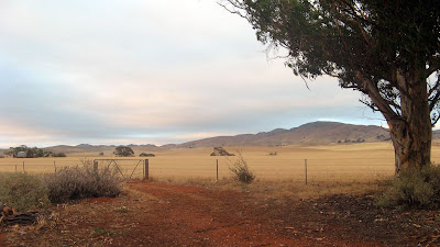
A lonely isolated road lead northwards away from the Old Wonoka ruins. Past the long forgotten graves with ornate cast iron fencing and a stone crypt. The road lay beside the former Great Northern Railway, which had once swept out to the north west to reach the plains. However, the road continued into the valley, that was covered in loose, red rocks, almost lunar-like.

Melrose to Quorn to Kanyaka to Mt Little Station
204km: 3 days


Beyond lay the Elder Range with it's great spine snaking in a giant animal-like curve before us. To our left lay a rock survey cairn, dry stacked stones carefully selected to rise several metres, constructed in the 1850s on a small hill strategically seen from an identical cairn on Rawnsley Bluff, on the edge of the distant Wilpena Pound.

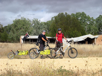
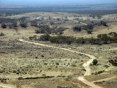
Here, in this seemingly empty valley, lay fresh 4WD tracks in the mud before us. It was tough riding, dodging the numerous rocks that lay on the track and the washaways. The sound of a 4WD coming over a crest before us took us by surprise, apparently returning along it's freshly laid tracks. We chatted with the driver, discovering that having just moved to Hawker a few weeks ago, he was exploring the route this track took him. He warned us of the steep descent that was to come. We had eyed off the elevation profile for several days, knowing it would bring an end to our three day ride, a quick steep descent back to our car. We were of course, wrong. A steep descent, indeed, but quick, certainly not. Covered in the same loose rock, it was very slow going, indeed, too slow. We had to contend with the bob trailer pushing the rear wheel out as it passed over large rocks, forcing us to jump off or fall off the bike.

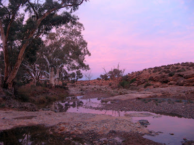
This was the third day of our ride. The previous night we had camped beside Kanyaka Creek, where there were large pools of water filled with recent rains, a perfect surface to reflect the deep pink and orange hues in the sky from the setting sun. After setting up camp and washing, we collected firewood so we could cook and eat fireside, as the moon rose behind us. The only thing to disturb the wonder of our sanctuary was the intermittent passing of a car or truck as it crossed the cattle grid on the nearby highway.

Early on the ride, when we first crossed this creek, we were witness to the enormity of the flood waters here on a day long past. Across the vast creek bed lay a huge, intact, steel girder from the adjacent bridge from the former Great Northern Railway. One of the three pillars had succumbed to the flooding of January, 2007, pulling down with it two of the massive girders. Only one of the girders could be seen, the other presumably carried further downstream. With a campsite a mere kilometre away, we were too tired to set off exploring for it.

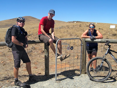
Friday night we had rendezvoused at Quorn before following each other north to Hawker. On a hill overlooking Hawker we selected a roadside camping spot close to where we could finish our ride three days later. The campsite was battered by a constant cold wind, but the following morning we were rewarded with views of the imposing Elder Range nearby, with Wilpena Pound stretching across the horizon beyond it. We drove the short distance to Mt Little station to drop off a car at our ride's end point, to which we would return in three days, before heading south back to Melrose, from where we would begin our three day ride.

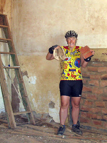
The ride from Melrose to Wilmington was uneventful, the straight flat roads quickly passing the kilometres. Sitting on the verandah of the general store at Wilmington, we ate the last two pies from the pie warmer. Beef & mushroom - I think - and a plain meat one. We had done the which-of-the-identical-paper-bags-does-this-pie-contain trick, and Nick had the fancy one. We marveled at how one small town could contain not one, but three, museums: a toy museum, puppet museum and a somewhat derelict military museum.

Perhaps the toughest part of the day, Richman Gap, lay in wait for us. It was a steep rocky 4WD track that wound its way through a pass, but beyond it was a six kilometre downhill run into Quorn. The 70 kilometre ride had been long, foreshadowing the long days that were to follow.

In Quorn, we set up camp beside Pinkerton Creek, albeit behind a two metre high security fence, in the Quorn Caravan Park. We received our eco-footprint discount, our camping fees amounting to a mere seven dollars fifty each. It should be noted though, the two of us had driven two cars up to the Flinders Ranges, leaving one at each end of our three day riding trek - it could hardly be counted as eco friendly.
After a hot shower, the cool of the evening prompted us to seek out the front bar of the Austral, one of Quorn's four pubs. Don't be mistaken though, the number of pubs doesn't so much indicate the population, but more so the long history of multiple pubs in this once busy railway town. Nick enjoyed a healthy serving of surf and turf, whilst I dug into chicken breast with chips and salad. No problem with finishing off the bread rolls or garlic bread either, clearly we had worked up quite an appetite.

Sunday we rode 66 kilometres to our Kanyaka Creek campsite, passing through Yarrah Vale Gorge Gap. From our vantage point on this winding road, we wondered upon the names of the hills that lay around us. Clearly though on the distant horizon lay Dutchmans Stern and Mt Arden. From numerous vantage points along today's ride we could see as far south as Mt Remarkable, where we had started on Friday morning, and Mt Brown, which we had passed by in Richmans Pass.

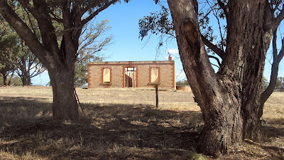
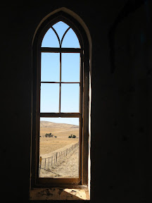
Eating lunch at Simmonston, touted as the Town That Never Was, surveyed with over 600 lots in early 1880s, along one of the nine possible routes for the Great Northern Railway. The railway was laid further east, via Hawker, dooming development of the town. All that remains today are a few stone ruins of the hotel and general store. The comparison below from Google Maps, showing the surveyed allotments on the left, and the absence of any development, on the right.


We had a seemingly endless ride across the Willochra Plain, one section at 7.5 kilometres long, slightly uphill into a headwind. After 5 kilometres or so, we sat on the road to rest from the monotony. Once riding again into the headwind, we were surprised by the sound of a car's horn behind us - a car evidently having driven up behind us on this remote road unbeknownst to either of us.

The final day was 67 kilometres, all three days were perhaps a little too far for us. Although each day had involved only some 6 hours on the road, each had left us quite exhausted, and me with increasingly sore knees. Alas, a worthwhile weekend out in the bush. I am just two to three days ride from the end of the Mawson Trail, but Graham coud not join us as this weekend as he was ill, so we will return to this area again later. I hope to spend a week out camping to complete the Mawson Trail later this year.


Stats

Mawson Trail
Friday Saturday Sunday
29/05/2009 30/05/2009 31/05/2009
Melrose to Quorn Quorn to Kanyaka Kanyaka to Mt Little Station
Distance 71.0km 64.9km 67.7km
Start Time 10.30am 9.02am 8.08am
End Time 4.17pm 4.02pm 2.16pm
Moving Duration 4h25m 4h38m 4h38m
Stationary Duration 1h21m 2h18m 1h26m
Moving Average 16.0km/h 13.9km/h 14.6km/h
Overall Average 12.3km/h 9.3km/h 11.1km/h
Oodometer 71.0km 135.8km 204.6km

Friday, April 17, 2009

Stone Hut to Melrose

A mere 52km to Melrose. Lunch at the North Star. A quick ride back to Stone Hut along the bitumen. Brrttthp.

Stone Hut to Melrose, return along bitumen road


Ah yeah, so had another Leave-Without-Pay-Day courtesy of the recession, so Graham and I decided to make the most of it and ride another day on the Mawson Trail. We would be up this way anyway for the weekend, hiking 63km along the Heysen Trail.

So the ride to Melrose was pretty cool. The lunch was fantastic. The ride back was maybe a little harder than expected, we though, from the advice we had sought from a keen cyclist, that it would be mostly downhill. It wasn't, well not until after Wirrabara, but it was still a good ride, just 2 hours back to Stone Hut.

These two photos are from Wirrabara Forest. I've heard tales of mud so thick through this forest that one couldn't ride a bike because of the mud that quickly accumulated between the wheel and frame. It seemed to be mostly dirt roads, and perhaps only a few of these seemed to hold the potential for this gripping mud. So easy to say huh?

Next 2 or 3 day ride in late May. Looking forward to it, getting back out with our bob trailers and camping.


Download kml file to view in Google Earth or adapt to use as a navigational aid in a GPS unit


Stats

Mawson Trail
Friday Friday
17/04/2009 17/04/2009
Near Stone Hut to Melrose (Mawson Trail) Melrose to near Stone Hut (via bitument road)
Distance 52.3km 39.9km
Start Time 8.02am 1.34pm
End Time 12.35pm 3.50pm
Moving Duration 3h33m 1h56m
Stationary Duration 1h02m 10m
Moving Average 14.7km/h 20.6km/h
Overall Average 11.4km/h 18.6km/h
Oodometer 52.3km 92.2km

Sunday, March 22, 2009

Introducing Wanda, Barbie and Jemima

My naming of my bike trailer, Bob, was ruled null and void by the others. The suggestion of B1, B2 and B3 collapsed with a lack of support. "Wanda," Nick said, as we passed Wanda Street in Spalding. And there it was, so the naming began.

Willalo Hall to Curnows Hut to Stone Hut
65km + 55km


Saturday was forecast for hot temperatures, but it came it cloudy in the morning after a speccie sunrise, and a cool change came in before lunch and with it a light sprinkling of refreshing rain. This was a long day, the longest yet on the trail - some 64km. The first climb of the day was from our previous ending spot at Willalo Hall up Camel Hump Range, location of the first stage of the Hallett Wind Turbine Project. Graham was blissfully unaware that he caused some bicycle-wary horses to bolt at the sight of him, jumping their paddock gate and galloping across the adjacent crop paddock into the hills. He must have been distracted by his enjoyment of the long kilometres of easy cruising at over 40km/h as we descended into the next valley.

We followed the Bundaleer Channels, which was winding but flat. The channels were constructed between 1898 and 1902, a series of channels that fed water from the local catchment area into a reservoir. There were lots of gates to contend with, and the grassey terrain made it a little harder. Other people riding this section have told of punctures and locked gates, but we encountered none of this. When I walked this section of the channels on the Heysen Trail in 2006, we also encountered a couple of fences without gates or locked gates, but this seems to have been since rectified. Apparently some riders have attempted to make the ride easier by riding along the bottom of the channel itself, although how they got into or out of the channel I don't know. As the system is no longer maintained, some sections are a little overgrown, and other sections blocked with debris or fencing. I could certainly see how at different times of the year riding along the channel pathways could be very difficult, denser grass or snake risk could be considerable.

Midway along the channels, the trail detours into Spalding. We parked our three bikes and trailers kerbside by the shop, clearly underestimating how busy a shop could get on a Saturday morning after local netball games. From here we rode further along the channels, before leaving them at one of the aquaducts the carries the channels over big creeks. Here we did put some serious deposits into the Hill Bank, from which we had very limited cashing in of on this day's ride. Near Washpool we battled with headwinds over the flat-ish track before a steep climb up Never Never Range. Even on the ridge top there seemed to be more uphill than down, and we finished the day with a mere 1.5km downhill run into Bundaleer Forest and our campsite for the night, Curnows Hut.

Sunday we continued through Bundaleer Forest, which made for beautiful albeit, slow riding. There were many gates to contend with, and the entry and exit gate from the public roads were both locked which is troublesome for our bikes with their trailers. After exiting the forest though, we got to cash in the deposits we had made in the Hill Bank, experiencing many long downhill runs towards Laura. After an identity crisis in Laura (why don't they make those pictures of men and women a little clearer on public toilets?) we rode the last distance towards Stone Hut, and our exit point from the Mawson Trail. We had left the car in Stone Hut, much to the display of the ever-friendly bakery owner, who had contacted the police in regards to the stolen and dumped car outside his bakery. Those theives though, how thoughtful of them to leave a clean and tidy, and locked, car.


Download Google Earth KML file of Mawson Trail

Download kml file to view in Google Earth or adapt to use as a navigational aid in a GPS unit:
The weekend's ride on the Mawson Trail
The Mawson Trail so far completed - Adelaide to near Stone Hut


Stats

Mawson Trail
Saturday Sunday
21/03/2009 22/03/2009
Willalo Hall to Curnows Hut Curnows Hut to Stone Hut
Distance 65.0km 55.1km
Start Time 8.27am 8.56am
End Time 5.27pm 3.51pm
Moving Duration 5h32m 3h41m
Stationary Duration 3h20m 2h55m
Moving Average 11.7km/h 14.9km/h
Overall Average 7.3km/h 8.3km/h
Max Speed 45.3km/h

Tuesday, March 17, 2009

Mt Bryan East to Willalo Hall

Continuing north along the trail near Mt Bryan East, we encountered more of that Flinders-esque landscape we had seen last ride. The view from Dares Hill Summit was rewarding, we could see for miles, although I had no real idea of what we were looking at. We left some scrub and re-entered farmland dramatically crossing Goyders Line.

Mt Bryan East to Willalo Hall
50km


Had a look-in at the the childhood home of Antartic explorer, Sir Hubert Wilkins. Cool that such an old homestead survived without even turn-of-the-century renovations, although I think it was abandoned a long time ago. I guess this is all in part due to it's isolation out there so close to Goyders Line.

Sir Hubert Wilkins was an amazing adventurer, yet unfortunately, most Australians know little of his incredible life. Sir Hubert Wilkins was born in 1888 just east of Hallett, in a humble outback cottage. His thirst for excitement and knowledge led him to enjoy a life rich with wondrous experiences. He went to the Antarctic, as a photographer and naturalist on several expeditions. 1926 saw Sir Hubert making experimental flights in the Arctic region, until 1928 when he made the first ever trans-Arctic flight from Alaska to Spitzbergen (3350km) in 205 hours. He was subsequently knighted as a result.

The Regional Council of Goyder, the Australian Geographic Society, Dick Smith, the National Trust and the volunteer based Sir Hubert Wilkins Memorial Trust Committee have restored the cottage of Sir Hubert's birthplace to its original condition.


Eating a late lunch in Hallett, thankful for the shop and lush green lawns by the local hall, we pushed on through some headwinds for Willalo Hall.


Download kml file to view in Google Earth or adapt to use as a navigational aid in a GPS unit


Stats

Mawson Trail
Mt Bryan East to Willalo Hall
Distance 51.3km
Start Time 10.01am
End Time 4.33pm
Moving Duration 3h43m
Stationary Duration 2h26m
Moving Average 13.8km/h
Overall Average 8.3km/h
Max Speed 40.0km/h

Sunday, March 15, 2009

Taking Bob out for a spin

Graham and I thought we might take our Bob trailers out for a bit of a trial run to get used to their handling.

Riverton to Auburn and return


We headed to Riverton to cover the section of Mawson Trail to Auburn. We had already been between these towns back in January, but we had gone via the Rattler Trail. This time we followed the true course of the Mawson Trail along the dirt roads, and I gotta say, it was much more interesting and scenic than the Rattler Trail, and a fair bit easier to ride.

Near Golf Course Road we came upon a locked gate. On the GPS map that I found on bikely.com the GPS track author had ridden around this locked road. The road beyond the gate was nothing more than an old road reserve and with the trail signs removed we could smell an angry landowner. So we rode around this section, taking a small short cut down the Rattler Trail. I think this just proved once and for all just how bad that rail trail really is, it is so rough, in desperate need of some finer gravel or rolling. We exited the Rattler near the famed spot where Graham had thrown his tanty last time. Later that day riding home the trail was still sign-posted in the opposite direction, so we decided we would ride the true trail. We found what appeared to be locked gates, and as we were preparing to unpack and lift our bob trailers and bikes over the gate we found the gates were not locked at all. This was also true of the gate we had first seen back on Golf Course Road! Stupid heads, should have inspected a bit closer.

In Auburn we had a yummy lunch at Cygnets, where we had eaten last time. I ordered the truly magnificent Caramelised Pear on Blue Cheese Bruschetta, my most favourite meal ever combining everything truly yummy. A few passers-by stopped to admire our Bob trailers.

There seemed to be more hills to contend with on our return ride to Riverton than we recalled going down, how easily those downhill runs are forgotten.

Overall, as expected, we were very impressed with the Bob trailers. Like pack hiking, one certainly notices the extra weight when you first set out on the trip, but you soon get used to it. Obviously due to the extra weight they still affect the performance of the bike, we had ours loaded with about 20kg of water to sumulate a normal touring weight. Nonetheless though a Bob trailer is far superior to panniers which grossly affect bike handling.


Download kml file to view in Google Earth or adapt to use as a navigational aid in a GPS unit


Stats

Mawson Trail
Sunday
15/03/2009
Riverton to Auburn Auburn to Riverton
Distance 20.5km 20.0km
Start Time 9.40am 1.10pm
End Time 12.10pm 2.58pm
Moving Duration 1h26m 1h34m
Stationary Duration 46m 13m
Moving Average 14.2km/h 12.6km/h
Overall Average 9.3km/h 11.1km/h
Max Speed 41.6km 38.7km
Oodometer 20.5km 40.5km

Sunday, February 22, 2009

The Farmer Wants a Wife

Perhaps a couple of days cycling through isolated farming and pastoral land with three guys was enough. Judith joined us for this weekend, and after a short soiree along the last 10km - all downhill - of the Riesling Trail, we left Clare and headed north-east to Burra. On an isolated dirt road, upon seeing Jude ride past, a local farmer stopped his tractor and combine harvester to jump out and "inspect his crop".

Penwortham to Burra to Mt Bryan East
2 days: 118km
Nick, Graham, Jude and myself


This didn't escape the notice of Jude, who was much impressed. He was a little older, granted, but as we rode on we wondered upon his riches and the vastness of his estate, contemplating which of the various sprawling farm homes would be his. As luck would have it, the Mawson Trail route took us straight past his house, it was clear to all that this is the house he was preparing for this new wife. Jude was in awe, it was hard not to be really. A sprawling house, almost ready to move in. Partly furnished, all it needed was a woman's touch. This was fate, there was just no doubt, the shoes the farmer left as gift were the perfect size. Also of note was the car parked in the shade under a nearby tree.

We drove up Friday night and stayed at a Heysen Hut - the old Mt Bryan East School. Nick slept in his campervan with Nicole and the kids, whilst Graham, Jude and I discussed the merits of sleeping in the building when the last comment left in the log book was from the previous weekend and commented on the appetite for human flesh the local field mice had. Well possibly it was me who was driving that conversation, but I had my mouse-proof tent handy which would ensure a sound nights sleep.

The following morning we were awoken to a windy morning with glorious sunrise colours. As we nibbled on our breakfast and played frisbee with Nick's kids, Olivia, 8 and Noah, 6, Graham busied himself wrapping his new bike in several metres of bubble wrap. Effectively protected against the hard metals of the other bikes in the trailer, we left my car at the hut and drove in the campervan down to Penwortham, just south of Clare, where we had ended our ride last month. With Graham, Nick and Nicole up front, Judith and myself discussed the finer points of an assignment which we set for Noah and Olivia. As we rode back to Burra, where they were set to spend the day with Nicole in Burra which would involve a look-in to the various op shops. The point system decided, each child selectively interpreted the list to their own liking. Noah was off to find a gun, preferably a working one, as they posed no danger, indeed, as Jude and I were sternly told, it was the bullets that were harmful. It was remiss of us though, as upon completion of their assignment the following day, it became clear to both children that we had been negligent in finding suitable rewards. Opps. Isn't the fun of it the reward?

The first day was tough, although we all took some delight in the roo racing we participated in, thankfully on a long downhill run from Camels Hump Range. So a big roo can easily bounce along at between 35-38km/h. I suggest you file that one away somewhere for it's possible use at a quiz night one day, you just never know.

Nearing Burra, we were met by Noah, Olivia and Nicole on their bikes. "Did anyone fall off?" asked Noah as we rode into town. "No," I replied. "Not even Graham?" Noah responded, clearly concerned that the bubble wrapping effort may have been in vain. Jude led the way to a apple wine place in Burra she had earlier seen advertised. We had expected to see it on the outskirts of Burra as we rode in from the southern side. As it turned out it was only about 150m from the trail, but not directly accessible from the trail, so we had to ride all the way into town, past our intended campsite on the outskirts, down to the main street, then back up a ridiculous hill the winery. And we had to do all this with the 4.30pm closing time looming. As we staggered in to the tasting area, I lingered outside for a moment to empty my water bottle over my head. Confronted with a selection of apple wines and liqueurs, each of us pleaded for a glass of water first. After a very interesting chat and the purchase of several bottles of wine and liqueur, we rode back to our campsite. We camped in an organic orchard grove on the southern outskirts of the town, belonging to a friend of Nick and Nicole. On site was some running water, a nice little caravan, and a huge stack of hay bales that provided much welcome shade in the setting sun. After a wash under the tap, we walked into town to dine at The White Cedars, the local Indonesian restaurant.

While Noah set his sights on conquering the huge plate of noodles before him, the rest of us shared our meals. It was all top food, I was particularly impressed with the gora gora (was that the name?). It was such a good meal, we forgot to take the photos of it we had planned.

To top off the fantastic meal, I think we all slept very well Saturday night. Sunday morning we were able to ride out of Burra early, a good thing given the predicted 33 degree temperature. Riding past Mokota Conservation Park we thought perhaps it more likely that this land had been donated as a conservation park rather than sought out, it looked to be nothing more than a treeless paddock atop a hill. No I lie, we could see two trees in the vast 450 hectares. Upon coming across the main entrance though, we could not have been more wrong. It was a conservation area for the native grasses, which had been extensive throughout this area prior to the devastation caused by agriculture.
It [Mokota Conservation Park] was proclaimed to protect the Lomandra multiflora ssp. dura / Lomandra effusa tussock grassland. It is one of the largest remaining examples of an open grassy vegetation community, which used to cover more than one million hectares of temperate Australia. Currently, this vegetation type covers less than 0.3% of the original extent due to clearance for agriculture.


After a lunch in the shade of some sparse but welcome trees, we climbed White Hill Road to the western extreme of the Mawson Trail. The view was amazing, and was a favourite spot of the weekend, this remote fringe pastoral land beyond Goyder's Line reminded us of the Flinders, with wide flat stony creekbeds, red rocks, winding roads and dramatic hills. After a long climb we enjoyed a long downhill ride, and Graham and Nick found a nice log to sit on under the shade of a small tree. Here after a long rest, as we rode off I glanced back to check we hadn't left anything. A handy little habit. I found myself a new camera, which I was much pleased with. Coincidentally, later on Graham discovered he lost his, so reluctantly I conceded it seemed fate was at play here and he should have this new found camera to replace his lost one.

Exiting the trail near Mt Bryan East, we rode back to the hut and car. The shade was a welcome relief, and the very cool water from the shaded water tank even better. After dissecting a few finer points of the ride, including how much further we could have ridden in the heat, we exchanged some words about team members finding other's lost possessions and then Graham re-wrapped his bike in bubble wrap for the trip home. Discussions ensued about our plans for the next weekend ride, and the special guest appearance by Ibex Bob on Saturday, which we deemed a success, may be the modus operandi of the next few rides as the campsites are fewer and far between. We certainly enjoyed the ease of our car plans this time around, last month had been a bit of a schmozzle, and it was good to not have to drive Saturday night or Sunday morning, and less driving around in general thanks in part to the car trailer.

Sitting kerbside back in Burra, we ate our ice creams, well two for Jude, not having been able to decide which might have been better. Back at the orchard we checked on how the kids had gone in their assignment. They had managed to find the Superhero book (2 points), a war item (a helicopter that had seen active service), a nine digit number (ISBN) and the biggest scorer, a pair of crutches.

Some more photos to come from Nick and Graham... Thanks for Jude for her 4 award winning photos.


Download kml file to view in Google Earth or adapt to use as a navigational aid in a GPS unit


Stats

Mawson Trail
Saturday Sunday
21/2/2009 22/2/2009
Penwortham to Burra Burra to Mt Bryan East
Distance 55.7km 52.9km
Start Time 10.43am 8.58am
End Time 5.19pm 3.18pm
Moving Duration 3h41m 3h57m
Stationary Duration 2h53m 2h22m
Moving Average 15.1km/h 13.4km/h
Overall Average 8.5km/h 8.4km/h
Max Speed 38.5km/h 40.6km/h
Oodometer 55.7km 108.6km