Introducing Wanda, Barbie and Jemima
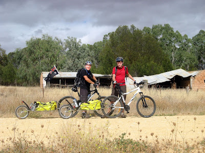
My naming of my bike trailer, Bob, was ruled null and void by the others. The suggestion of B1, B2 and B3 collapsed with a lack of support. "Wanda," Nick said, as we passed Wanda Street in Spalding. And there it was, so the naming began.
Willalo Hall to Curnows Hut to Stone Hut
65km + 55km
65km + 55km
 Saturday was forecast for hot temperatures, but it came it cloudy in the morning after a speccie sunrise, and a cool change came in before lunch and with it a light sprinkling of refreshing rain. This was a long day, the longest yet on the trail - some 64km. The first climb of the day was from our previous ending spot at Willalo Hall up Camel Hump Range, location of the first stage of the Hallett Wind Turbine Project. Graham was blissfully unaware that he caused some bicycle-wary horses to bolt at the sight of him, jumping their paddock gate and galloping across the adjacent crop paddock into the hills. He must have been distracted by his enjoyment of the long kilometres of easy cruising at over 40km/h as we descended into the next valley.
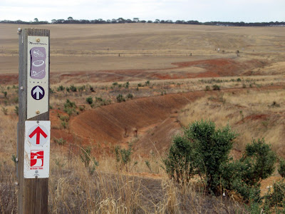 We followed the Bundaleer Channels, which was winding but flat. The channels were constructed between 1898 and 1902, a series of channels that fed water from the local catchment area into a reservoir. There were lots of gates to contend with, and the grassey terrain made it a little harder. Other people riding this section have told of punctures and locked gates, but we encountered none of this. When I walked this section of the channels on the Heysen Trail in 2006, we also encountered a couple of fences without gates or locked gates, but this seems to have been since rectified. Apparently some riders have attempted to make the ride easier by riding along the bottom of the channel itself, although how they got into or out of the channel I don't know. As the system is no longer maintained, some sections are a little overgrown, and other sections blocked with debris or fencing. I could certainly see how at different times of the year riding along the channel pathways could be very difficult, denser grass or snake risk could be considerable.
Midway along the channels, the trail detours into Spalding. We parked our three bikes and trailers kerbside by the shop, clearly underestimating how busy a shop could get on a Saturday morning after local netball games. From here we rode further along the channels, before leaving them at one of the aquaducts the carries the channels over big creeks. Here we did put some serious deposits into the Hill Bank, from which we had very limited cashing in of on this day's ride. Near Washpool we battled with headwinds over the flat-ish track before a steep climb up Never Never Range. Even on the ridge top there seemed to be more uphill than down, and we finished the day with a mere 1.5km downhill run into Bundaleer Forest and our campsite for the night, Curnows Hut.
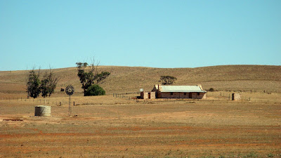
Sunday we continued through Bundaleer Forest, which made for beautiful albeit, slow riding. There were many gates to contend with, and the entry and exit gate from the public roads were both locked which is troublesome for our bikes with their trailers. After exiting the forest though, we got to cash in the deposits we had made in the Hill Bank, experiencing many long downhill runs towards Laura. After an identity crisis in Laura (why don't they make those pictures of men and women a little clearer on public toilets?) we rode the last distance towards Stone Hut, and our exit point from the Mawson Trail. We had left the car in Stone Hut, much to the display of the ever-friendly bakery owner, who had contacted the police in regards to the stolen and dumped car outside his bakery. Those theives though, how thoughtful of them to leave a clean and tidy, and locked, car.
Download Google Earth KML file of Mawson Trail |
Download kml file to view in Google Earth or adapt to use as a navigational aid in a GPS unit: • The weekend's ride on the Mawson Trail • The Mawson Trail so far completed - Adelaide to near Stone Hut |
| Stats | Mawson Trail | ||
| Saturday | Sunday | ||
| 21/03/2009 | 22/03/2009 | ||
| Willalo Hall to Curnows Hut | Curnows Hut to Stone Hut | ||
| Distance | 65.0km | 55.1km | |
| Start Time | 8.27am | 8.56am | |
| End Time | 5.27pm | 3.51pm | |
| Moving Duration | 5h32m | 3h41m | |
| Stationary Duration | 3h20m | 2h55m | |
| Moving Average | 11.7km/h | 14.9km/h | |
| Overall Average | 7.3km/h | 8.3km/h | |
| Max Speed | 45.3km/h | ||